


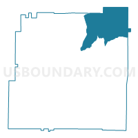
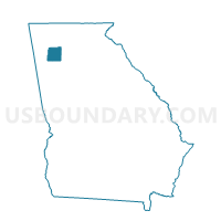
01512 - PINE LOG Voting District, Bartow County, Georgia
About
Outline

Summary
| Unique Area Identifier | 560310 |
| Name | 01512 - PINE LOG Voting District |
| County | Bartow County |
| State | Georgia |
| Area (square miles) | 45.60 |
| Land Area (square miles) | 45.59 |
| Water Area (square miles) | 0.01 |
| % of Land Area | 99.97 |
| % of Water Area | 0.03 |
| Latitude of the Internal Point | 34.36347200 |
| Longtitude of the Internal Point | -84.72742760 |
Maps

Graphs
Select a template below for downloading or customizing gragh for 01512 - PINE LOG Voting District, Bartow County, Georgia


Neighbors
Neighoring Voting District (by Name) Neighboring Voting District on the Map
- 01509 - FOLSOM Voting District, Bartow County, GA
- 01515 - WHITE Voting District, Bartow County, GA
- 057033 - SALACOA Voting District, Cherokee County, GA
- 057041 - WALESKA Voting District, Cherokee County, GA
- 1291056 - SONORAVILLE Voting District, Gordon County, GA
- 129874 - FAIRMOUNT Voting District, Gordon County, GA
- 2274 - JERUSALEM Voting District, Pickens County, GA
Top 10 Neighboring County Subdivision (by Population) Neighboring County Subdivision on the Map
- White-Pine Log CCD, Bartow County, GA (11,201)
- Waleska CCD, Cherokee County, GA (7,772)
- Fairmount CCD, Gordon County, GA (6,929)
- Ludville CCD, Pickens County, GA (3,701)
Top 10 Neighboring Unified School District (by Population) Neighboring Unified School District on the Map
- Cherokee County School District, GA (214,346)
- Bartow County School District, GA (80,433)
- Gordon County School District, GA (39,599)
- Pickens County School District, GA (29,431)
Top 10 Neighboring State Legislative District Lower Chamber (by Population) Neighboring State Legislative District Lower Chamber on the Map
- State House District 21, GA (75,926)
- State House District 15, GA (58,888)
- State House District 14, GA (58,382)
- State House District 12, GA (56,194)
Top 10 Neighboring State Legislative District Upper Chamber (by Population) Neighboring State Legislative District Upper Chamber on the Map
- State Senate District 27, GA (264,822)
- State Senate District 51, GA (190,842)
- State Senate District 54, GA (173,407)
- State Senate District 52, GA (168,885)
Top 10 Neighboring 111th Congressional District (by Population) Neighboring 111th Congressional District on the Map
- Congressional District 9, GA (823,583)
- Congressional District 11, GA (794,969)
- Congressional District 6, GA (767,798)
Top 10 Neighboring Census Tract (by Population) Neighboring Census Tract on the Map
- Census Tract 9601.02, Bartow County, GA (9,507)
- Census Tract 902, Cherokee County, GA (7,772)
- Census Tract 9709, Gordon County, GA (6,929)
- Census Tract 504, Pickens County, GA (3,701)
- Census Tract 9601.01, Bartow County, GA (1,694)
Top 10 Neighboring 5-Digit ZIP Code Tabulation Area (by Population) Neighboring 5-Digit ZIP Code Tabulation Area on the Map
- 30121, GA (22,078)
- 30103, GA (14,781)
- 30184, GA (6,847)
- 30183, GA (5,282)
- 30139, GA (3,845)
- 30171, GA (3,491)